Unplanned power outage in Uniondale
Electricians are on site.
Electricians are on site.
Unplanned power outage in New Dawn Park and Andersonville in Pacaltsdorp
Issued by George Municipality 29 April 2024 at 11h15
Electricians are on site to investigate.

GO GEORGE SCHEDULES ON UPCOMING PUBLIC HOLIDAYS
With two public holidays coming up, GO GEORGE calls on passengers to take note of the schedules that will be followed on these days.
Freedom Day (Saturday 27 April) will follow the normal Saturday schedule. The Saturday timetable will also apply on Workers’ Day (Wednesday 1 May).
For any enquiries or assistance with trip planning, phone the GO GEORGE Call Centre on 0800 044 044, or visit the GO GEORGE website at www.gogeorge.org.za to see the Saturday timetables.
GO GEORGE-SKEDULES OP KOMENDE VAKANSIEDAE
Met twee openbare vakansiedae voor die deur, vestig GO GEORGE passasiers se aandag op die skedules wat op hierdie dae gevolg sal word.
Op Vryheidsdag (Saterdag 27 April) sal die gewone Saterdagskedule geld op alle roetes. Die Saterdagskedule word ook op Werkersdag (Woensdag 1 Mei) gevolg.
Vir enige navrae of hulp met ritbeplanning, skakel gerus die GO GEORGE-inbelkantoor by 0800 044 044, of besoek die GO GEORGEwebblad by www.gogeorge.org.za om die Saterdagskedule te bestudeer.

NOTIFICATION OF THE INTERRUPTION OF THE ELECTRICITY SUPPLY.
THE FOLLOWING AREAS WILL BE AFFECTED:
PORTION OF GEORGE CENTRAL
COURTNEY STREET AND MERRIMAN STREET
NOTICE is hereby given that the electricity supply will be interrupted on SATURDAY 27 APRIL 2024 FROM 14H00 TO 17H00 for the purpose of doing alterations to the electrical mains. Consumers are warned to treat the installation as being live for the full duration as the supply may be resumed at any time within the notified period.
Should circumstances prevent the work being carried out during the abovementioned period; the work will be done on SUNDAY 28 APRIL 2024 FROM 09H00 TO 16H30.
KENNISGEWING VAN DIE ONDERBREKING VAN DIE ELEKTRIESE TOEVOER
DIE VOLGENDE AREAS SAL GERAAK WORD:
GEDEELTE VAN GEORGE SENTRAAL
COURTNEY STRAAT EN MERRIMAN STRAAT
KENNISGEWING geskied hiermee dat die elektriese toevoer onderbreek sal word op SATERDAG 27 APRIL 2024 VANAF 14H00 TOT 17H00 met die doel om veranderings aan elektriese hoofleidings te maak. Klante word gewaarsku om die installasie as lewendig te beskou vir die volle periode aangesien die toevoer enige tyd gedurende die periode aangeskakel mag word.
Sou omstandighede verhoed dat die werk gedoen kan word gedurende bogenoemde periode, sal die werk gedoen word op SONDAG 28 APRIL 2024 VANAF 09H00 TOT 16H30.
The George Municipal Financial Directorate is pleased to announce the availability of a new rates estimate calculator on the city’s official website. This tool offers a convenient solution for property owners to estimate their rates with ease.
The current version of the calculator has been configured with the 2023/24 tariff model, ensuring accuracy in calculations. It is important to note that the final tariffs for the 2024/25 financial year will be integrated into the calculator following approval by the Council in May 2024. To access the rates calculator, kindly follow the provided link to our website. We advise all users to carefully read the disclaimer before proceeding, and to acknowledge their understanding by ticking the designated box.
Link to Rates Calculator https://tinyurl.com/mtj7n8hk

In the photo above Ward Councillors and Ward Committee participants attending the Public Participation Feedback Engagement and Open Day last week at the Pacaltsdorp Community Hall.
The Integrated Development Planning and Public Participation unit in the Directorate of Planning and Development held a public participation feedback engagement and open day last week with Ward Committees in Pacaltsdorp Community Hall. Whitney Prins, Manager: IDP and Public Participation, said the platform was created for meaningful engagement and collaboration within our communities. She said the discussions regarding the feedback received on the 10 Capital and 10 operational ward-specific requirements, stemming from the initial round of public participation held across all wards in 2022 was of vital importance.
She said the primary objective is to keep communities informed about the developments and initiatives undertaken by George Municipality as well as sector departments that fall outside the scope of George Municipality’s mandate. In addition to the feedback sessions, the budget for the upcoming financial year was also discussed. Service departments gave a concise overview of their respective roles and responsibilities, as well as explained how they prioritize requests originating from Wards. Information was also provided regarding electricity, roads, EPWP and water meters.
Photos 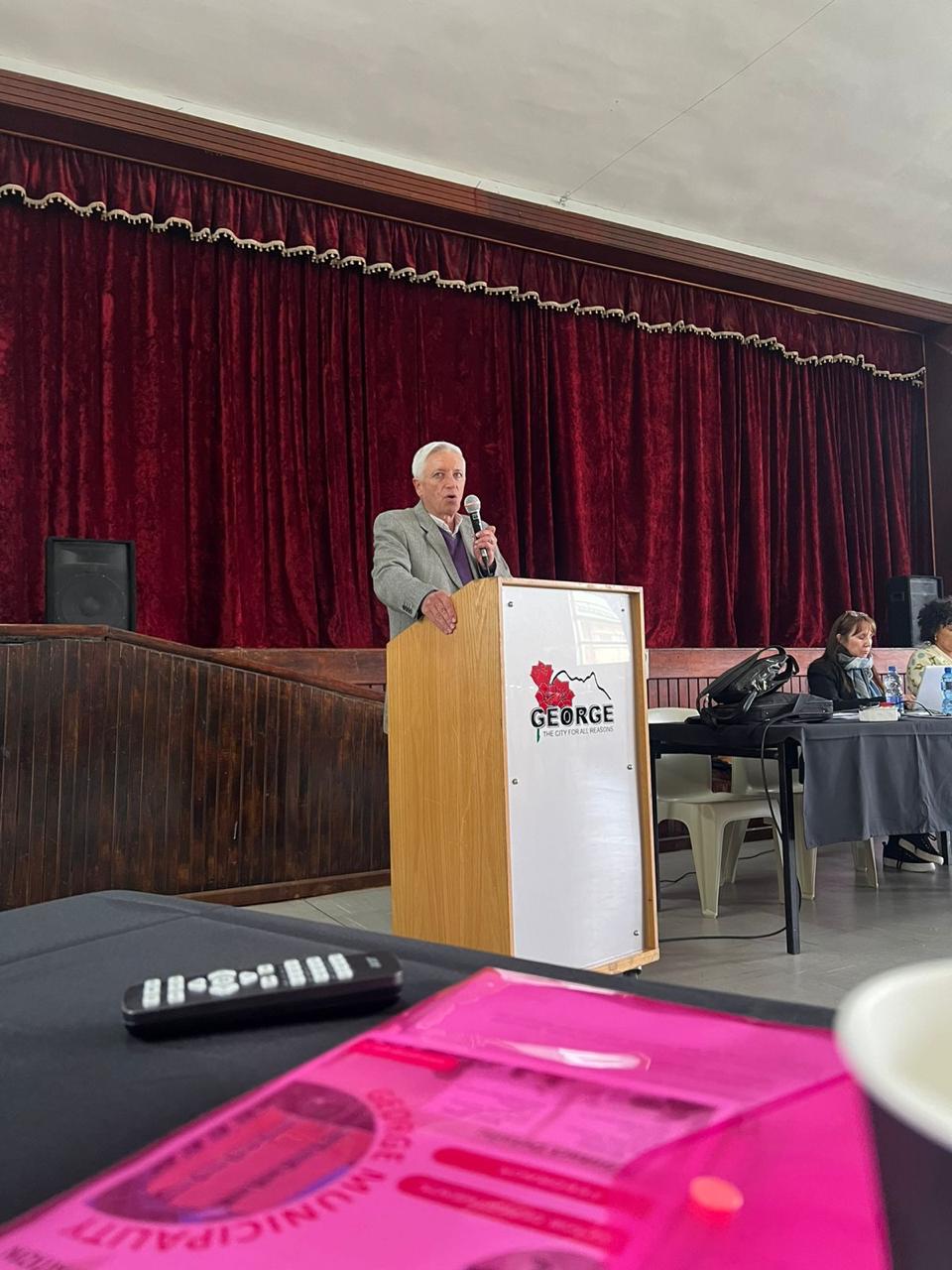 George Mayor, Ald Leon van Wyk, addresses the participants at the Public Participation Feedback Engagement in Pacaltsdorp
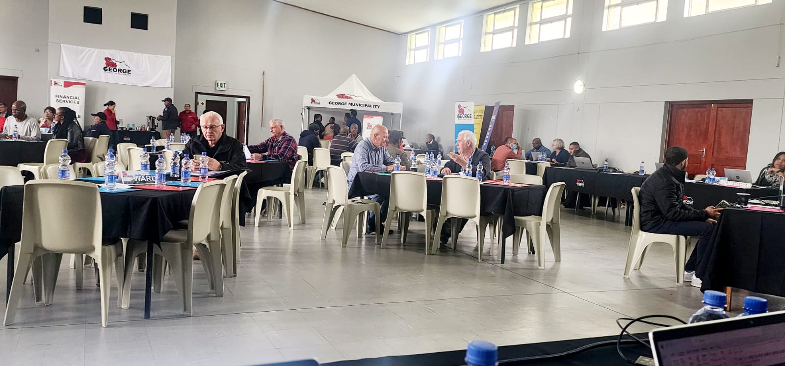
Ward Councillors and Ward Committee participants attending the Public Participation Feedback Engagement and Open Day last week at the Pacaltsdorp Community Hall.
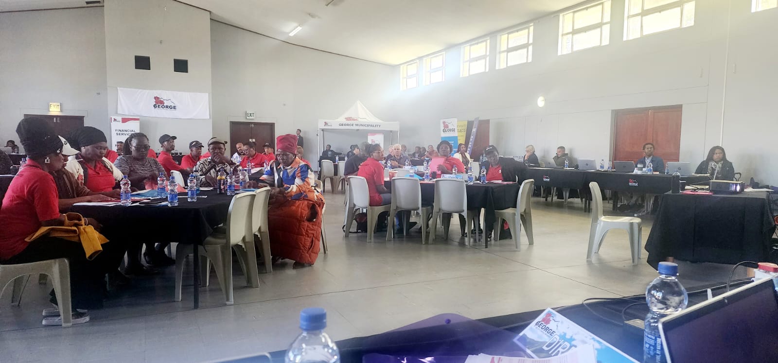
Ward Councillors and Ward Committee participants attending the Public Participation Feedback Engagement and Open Day last week at the Pacaltsdorp Community Hall.
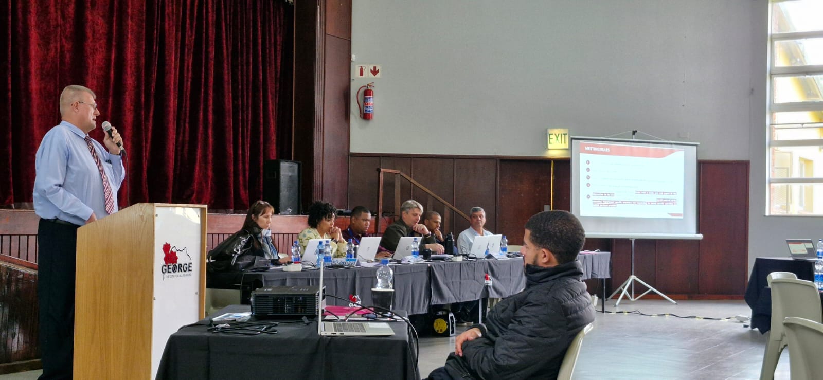
Cllr Sean Snyman, Speaker of George Council and custodian of Public Participation and Ward Committees addresses the participants at the Open Day.
Percentage storage at new raised dam wall height 100 %
Rainfall for the previous days: 6mm (Measured rainfall figures from 15 April until 22 April 2024)
For water-saving tips please visit: http://tinyurl.com/3439h4n7
The cooperation of all users of municipal water is essential and is greatly appreciated.
In die foto hierbo George Burgemeester, Leon van Wyk, oorhandig ‘n tjek van R50 000 ter ondersteuning van die George Outeniqua Marathon aan Duppie du Preez (President: Outeniqua Harriers) en Sakkie Stoffberg (Tesourier: Outeniqua Harriers), die organiseerders van die wedloop.
George Burgemeester, rdh. Leon van Wyk, het ‘n tjek van R50 000 aan die Outeniqua Harriers oorhandig ter ondersteuning van die George Outeniqua Marathon, ‘n gewilde jaarlikse wedloop vir die afgelope 40 jaar, waarvan die George Munisipaliteit ‘n vennoot is.
Volgens Duppie du Preez, President van Outeniqua Harriers, vind die wedloop vanjaar Saterdag 27 April 2024 plaas. Dis ’n belangrike wedloop op die kalender van Atletiek SWD en die marathon van 42,2km dien as die heel laaste Comrades kwalifiserende wedlope.
Du Preez het gesê die George Munisipaliteit is ‘n belangrike vennoot om die wedloop jaarliks n sukses te maak.
Van Wyk het gesê die wedloop is legendaries en dit vind plaas langs die mooiste roetes in die land met uitsigte op die berge, bos en see asook ons Tuinroete dam wat 100% vol is. Die burgemeester het gesê George Munisipaliteit is ’n trotse vennoot in die wedloop en ondersteun die gebeurtenis uit die geleenthede-begroting.
Atlete van oor die hele Suid-Afrika neem deel en die wedloop het in 2023 bykans ‘n 1000 atlete getrek. Hy het gesê hoewel 2024 se wedloop nie oor ‘n langweek plaasvind nie, hoop Outeniqua Harriers steeds dat atlete weer in getalle sal opdaag .
Daar is 3 verskillende wedlope naamlik n 42,2km, 21,1km en ‘n 10km.
Die 42,2km begin by die TRAIL KIOSK in Camphersdrift om 07h00, die 21,1km by die Tuinroetedam om 08h00 en die 10km by die Wilderness Commonage (oop ruimte oorkant die Wilderness Hotel )om 08h00. Al die wedlope word voltooi by die Wilderness Commonage.
Aanlyn Inkrywings vir die wedloop het reeds gesluit ,maar laat inskrywings kan steeds Vrydag middag 26 April 2024 vanaf 16h00 tot 21h00 by die Trail Kiosk gemaak word vir al drie wedlope. Atlete kan nog Saterdagoggend vanaf 07h00 inskryf vir die 10km in Wilderness.
Prysgeld is beskikbaar aan kategorie-wenners en medaljes aan alle atlete wat die wedloop voltooi.
Daar is verskeie gelukkige trekkigs met amper 20 paar skoene van Pivot en Mount CO asook groot verblyfspryse van Lovain Gasteplaas en ander plaaslike besighede. Vir enige verdere navrae kontak Esme Boshoff by 084 499 7753.

The George Municipality would like to urge private landowners to act and clear Cortaderia selloana, commonly known as Pampas grass which is invading the George Area again.
George Municipality is currently clearing the Pampas grass on Municipal property in line with its Alien Vegetation Management Plan.
The Pampas grass has become prolific around the industrial areas, along the highways, local dams, and factory areas. For the past month, Pampas grass has been cleared along CJ Langenhoven Road, portions of the Garden Route Dam, Madiba Road, Municipal properties in the industrial area, Dellville Park along the N2 and municipal erfs along Beach Road, Pacaltsdorp.
George Municipality applauds residents who were given the notice to remove pampas on their private property and have cooperated well in their actions. The Municipality wants to thank these residents for the positive response.
Pampas grass seeds can be dispersed by wind and human activities. It can germinate quickly after flowering causing them to spread rapidly. George Municipality has requested the Department of Forestry, Fisheries and Environment to give notices and directives to private properties that do not clear their pampas grass. It would be advisable to get rid of the grass in its early growth stage before it flowers and produces seeds that can be easily dispersed by wind. The methods that can be used to remove pampas grass include digging, burning, and using herbicides.
The process of eradicating pampas grass is not a one-size-fits-all, but it is important to note that the most effective way to remove pampas grass is to use both the physical and chemical methods simultaneously. Private landowners can contact the George Municipality Parks and Recreation Department for details on registered and approved herbicides for the control of Pampas grass.
Enquiries
Parks and Recreation, Directorate Community Services
82 Meade Street, George
044 802 2900
parks@george.gov.za (all complaints via this address)
School learners and young adults are invited to a Career Expo at George Library that is being held tomorrow, Tuesday 23 April 2024 and runs from 11:00 to 14H00.
According to Malibongwe Luyenge, Senior Librarian at George Municipality, this event aims to provide valuable information and insights to students about various career paths and opportunities available to them.
The programme for the day is as follows:
10:30 – 11:00 Set up stalls and preparation
11:30 – 11:37 Presentation by Forensic Pathology Services
Presenters: Mzoxolo Panduva and Kenwyn Barnardo
11:37 – 11:44 Presentation by George Police Service (SAPD)
11:44 – 11:53 Presentation by ER 24
11:53 – 12:00 Presentation by Africa Skills
12:00 – 12:07 Presentation by Francois Ferreira Academy
12:07 – 12:14 Presentation by South Cape College
12:14 – 12:21 Presentation by Nelson Mandela University
12:21 – 12:28 Presentation by Fire Department
12:28 – 12:35 Presentation by Shirlock Dixon (Jewellery Maker / Mechanic / Panel beater and Spraypainter)
12:35 – 12:42 Presentation by Fabian Campher (Barber / Tattoo Artist / Body Builder)
12:42 – 12:49 Presentation by Nip and Cut (Hair Dresser and Nail Technician)
12:56 – 13:03 Presentation by Toyota (Peter)
13:03 – 13:10 Students visit stalls of their choice
13:10-13:17 Sonja Smith Elite Funeral Group
Students will have the opportunity to visit the stalls after the presentations to learn more about each organisation and career path. Some of the schools that confirmed attendance are Parkdene High School, House Outeniqua, Country House, George High School and Heatherlands High School. Luyenge said they are excited to have such a diverse range of participants and schools at the event, and we hope it will be a valuable and enriching experience for all involved. He thanked all stakeholders for supporting the career development of students.
Any schools that are still interested in attending the event can phone Luyenge on 044 801 9199/9288 or email mluyenge@george.gov.za or rwilliams@george.gov.za
NOTIFICATION OF THE INTERRUPTION OF THE ELECTRICITY SUPPLY.
THE FOLLOWING AREAS WILL BE AFFECTED:
PORTION OF PACALTSDORP INDUSTRIA,
CRUSADER CLOSE AND PIONEER ROAD.
NOTICE is hereby given that the electricity supply will be interrupted on SUNDAY 21 APRIL 2024 FROM 07H00 TO 18H00 for the purpose of doing alterations to the electrical mains. Consumers are warned to treat the installation as being live for the full duration as the supply may be resumed at any time within the notified period.
Should circumstances prevent the work being carried out during the abovementioned period; the work will be done on MONDAY 22 APRIL 2024 FROM 09H00 TO 16H30.
KENNISGEWING VAN DIE ONDERBREKING VAN DIE ELEKTRIESE TOEVOER.
DIE VOLGENDE AREAS SAL GERAAK WORD:
GEDEELTE VAN PACALTSDORP INDUSTRIA,
CRUSADER CLOSE EN PIONEER WEG.
KENNISGEWING geskied hiermee dat die elektriese toevoer onderbreek sal word op SONDAG 21 APRIL 2024 VANAF 07H00 TOT 18H00 met die doel om veranderings aan elektriese hoofleidings te maak. Klante word gewaarsku om die installasie as lewendig te beskou vir die volle periode aangesien die toevoer enige tyd gedurende die periode aangeskakel mag word.
Sou omstandighede verhoed dat die werk gedoen kan word gedurende bogenoemde periode, sal die werk gedoen word op MAANDAG 22 APRIL 2024 VANAF 09H00 TOT 16H30.
In the photo above Estelle Fredericks, Social Auxiliary Worker in the Community Development Services department, showcasing the products created by the workgroup. The assortment includes bags of various sizes and shapes, as well as indoor and outdoor aprons for braaiing, available for purchase at the Community Development office located at the corner of Varing and St. John’s Streets in town.
The George Municipality has initiated a work project for a segment of the homeless population, training them in sewing. Their first products now available for purchase, including beautiful handbags, sling bags, indoor, and outdoor aprons for braaiing, have been crafted using donated materials with the assistance of a single sewing machine.
Estelle Fredericks, a Social Auxiliary Worker in the Community Development Services department at George Municipality, stated that although the group of seven participants remained homeless, they convened every workday at the community development offices to engage in their projects. Fredericks emphasized that the project aims to support the group economically and eventually facilitate their transition from the streets. Profits from sales will be reinvested to purchase a second sewing machine, enabling more homeless individuals to join and learn to create products. Additionally, the department is in the process of launching a woodwork project to complement the sewing initiative, thereby expanding the range of products available for sale.
Members of the public interested in purchasing any of the products are encouraged to visit the Community Development offices located at the intersection of Varing and St John’s Street. Purchases can be made directly from the participants during their work hours, or customers can discuss their own design preferences and place custom orders. Apart from handbags and aprons, the group also offers curtain production and clothing repair and alteration services.
For further inquiries regarding purchasing items or donating materials, please contact Estelle Fredericks at 044 802 2000.

NOTIFICATION OF THE INTERRUPTION OF THE ELECTRICITY SUPPLY.
THE FOLLOWING AREAS WILL BE AFFECTED:
PORTION OF PACALTSDORP
DISA STR ,ARAM STR,ERICA STR,GLOXINA STR, FERN RD,TULIP STR AND CRESENT DRIVE.
NOTICE is hereby given that the electricity supply will be interrupted on FRIDAY 19 APRIL 2024 FROM 09H00 TO 16H30 for the purpose of doing alterations to the electrical mains.
Consumers are warned to treat the installation as being live for the full duration as the supply may be resumed at any time within the notified period.
Should circumstances prevent the work being carried out during the abovementioned period; the work will be done on MONDAY 22 APRIL 2024 FROM 09H00 TO 16H30.
KENNISGEWING VAN DIE ONDERBREKING VAN DIE ELEKTRIESE TOEVOER.
DIE VOLGENDE AREAS SAL GERAAK WORD:
GEDEELTE VAN PACALTSDORP
DISA STR, ARAM STR,ERICA STR,GLOXINA STR, FERN WEG,TULIP STR EN CRESENT RYLAAN.
KENNISGEWING geskied hiermee dat die elektriese toevoer onderbreek sal word op VRAYDAG 19 APRIL 2024 VANAF 09H00 TOT 16H30 met die doel om veranderings aan elektriese hoofleidings te maak. Klante word gewaarsku om die installasie as lewendig te beskou vir die volle periode aangesien die toevoer enige tyd gedurende die periode aangeskakel mag word.
Sou omstandighede verhoed dat die werk gedoen kan word gedurende bogenoemde periode, sal die werk gedoen word op MAANDAG 22 APRIL 2024 VANAF 09H00 TOT 16H30.
In the photo above, damage through an incident such as this can cause the driver to lose control of the bus as his vision is suddenly obstructed by the shattered glass. It could result in serious injuries and death of passengers and staff on the bus. The replacement cost in this case was about R20 000.
A total of 38 incidents of stone-throwing at GO GEORGE buses have been reported since April last year. The repair of damaged bus windows during this period has cost the George Public Transport Network (GIPTN) R544 470.
“Vandalism of GO GEORGE infrastructure and buses is a serious concern as it affects the quality of the service experience of our passengers and detracts from our mission of delivering a dignified and safe public transport service,” said Morné Lakay, GO GEORGE Manager. “A damaged bus is taken out of service for repairs, which places pressure on the existing fleet. Delays in coordinating a replacement bus may lead to a ripple effect where the service for the day runs late.”
According to Lakay, acts of vandalism often occur as a prank and may not be seen as a crime. “But damaging public property is a criminal offence and culprits will be treated as such and prosecuted, ending up with a criminal record. Throwing stones at a bus is a senseless act of vandalism. It endangers the lives of passengers and staff and can cause serious injuries.”
Most at risk are buses – damage to windows as well as seats inside the bus – and public infrastructure at the bus stops such as glass panels and service information stickers in the bus shelters.
Lakay says they are appealing to the community to become involved by promoting ownership and territorial responsibility towards buses and bus facilities in their area. “We need the help of parents, teachers, community influencers, youth leaders, religious and business organisations to instil the right values in youngsters, to make them understand the consequences of their ‘pranks’ and to put a stop to the senseless attack on a service that benefits their own community.”
GO GEORGE appeals to the public to discourage and help stop vandalism and to report any vandalising activities by phoning the GO GEORGE Call Centre on 0800 044 044. Photos of the culprits in the act, without endangering the photographer, will be very helpful.
CAPTION:
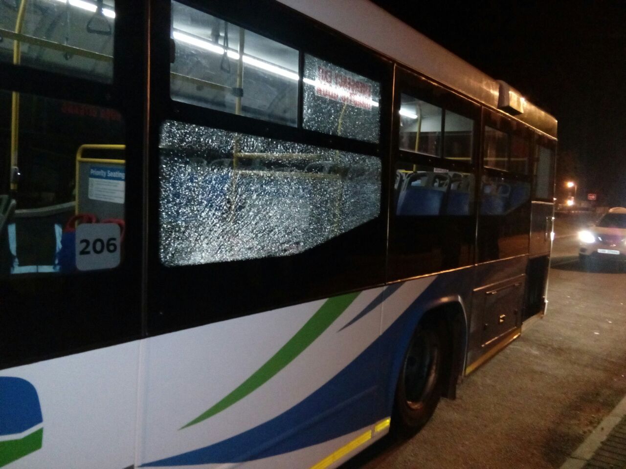
In a case like this, a stone or brick thrown at a bus could break through the window and land on passengers. It costs R19 100 to replace this window. GO GEORGE appeals to the public to discourage and help stop vandalism.
R544 470 vir stukkende busvensters in een jaar
Uitgereik Maandag 15 April 2024
Altesaam 38 voorvalle van klipgooiery na GO GEORGE-busse is sedert April verlede jaar aangemeld. Die herstel van beskadigde busvensters gedurende hierdie tydperk het die George Openbare Vervoernetwerk (GIPTN) R544 470 gekos.
“Vandalisme van GO GEORGE-infrastruktuur en busse is ‘n ernstige bron van kommer aangesien dit die gehalte van die dienservaring van ons passasiers beïnvloed en afbreuk doen aan ons missie om ‘n waardige en veilige openbare vervoerdiens te lewer,” het Morné Lakay, GO GEORGE-bestuurder, gesê. “‘n Beskadigde bus word uit diens onttrek vir herstelwerk, wat druk op die oorblywende vloot plaas. Vertragings met die koördinering van ‘n vervangingsbus kan tot ‘n rimpeleffek lei waar die diens vir die hele dag laat loop.”
Volgens Lakay word dade van vandalisme dikwels as ‘n poets gesien sonder om dit as ‘n misdaad te beskou. “Maar die beskadiging van openbare eiendom is ‘n kriminele oortreding en skuldiges sal as sodanig behandel en vervolg word, wat met ‘n kriminele rekord eindig. Om klippe na ‘n bus te gooi is ‘n sinnelose daad van vandalisme. Dit stel passasiers en personeel se lewens in gevaar en kan ernstige beserings veroorsaak.”
Die grootste risiko is busse – skade aan vensters asook sitplekke in die bus – en openbare infrastruktuur by die bushaltes soos glaspanele en diensinligtingsplakkers in die busskuilings.
Lakay sê hulle doen ‘n beroep op die gemeenskap om betrokke te raak deur eienaarskap en territoriale verantwoordelikheid teenoor busse en busgeriewe in hul omgewing te bevorder. “Ons het die hulp van ouers, onderwysers, gemeenskapsbeïnvloeders, jeugleiers, godsdiens- en sake-organisasies nodig om die regte waardes by jongmense te vestig, om hulle die gevolge van hul ‘poetse’ te laat verstaan en om die sinnelose aanval op ‘n diens wat hul eie gemeenskap bevoordeel, stop te sit.”
GO GEORGE doen ‘n beroep op die publiek om vandalisme te ontmoedig en stop te sit en om enige vandaliserende aktiwiteite aan te meld deur die GO GEORGE-inbelsentrum by 0800 044 044 te skakel. Foto’s van die skuldiges op die daad, sonder om die fotograaf in gevaar te stel, sal baie nuttig wees.
BYSKRIFTE:
1. Skade deur ‘n voorval soos hierdie kan veroorsaak dat die bestuurder beheer oor die bus verloor, aangesien sy visie skielik deur die gebreekte glas belemmer word. Die vervangingskoste in hierdie geval het omtrent R20 000 beloop.
2. In ‘n geval soos hierdie kan ‘n klip of baksteen wat na ‘n bus gegooi word, deur die venster breek en op passasiers beland. Dit kos R19 100 om hierdie ruit te vervang. GO GEORGE doen ‘n beroep op die publiek om vandalisme te ontmoedig en te help om dit stop te sit.

Beneficiaries of the new houses and officials are from left, Jennifer Davids (beneficiary), Portfolio Councillor for Human Settlements, Cllr Jean Safers, Brumilda Kirchner, Project Administrator at Human Settlements, Hester Tamboer (beneficiary in the wheelchair) with her husband next to her, Pieter, and on the far right is Cllr Regina Windwaai.
George Portfolio Councillor for Human Settlements, Cllr Jean Safers, handed nine houses over to beneficiaries at the Metro Grounds Housing Project last week.
Up until now 38 homes have been handed over to beneficiaries besides the 9 homes handed over last week. In total, 436 homes will be occupied at Metro Grounds once the project is finished.
According to Wendy Mentor, Acting Deputy Director: Human Settlements, beneficiaries for the Metro Grounds Housing Project have been taken from the Housing Demand Database. The beneficiaries are selected from those who have been on the waiting list for longest time, 60 years and older, disabled, farm workers, and persons residing in Informal Settlements.
Cllr Safers stated that it is the intention of the government of the day to house people as soon as possible. “We are just as happy with the families that received their homes. The era of leaking roofs and washing in old fashioned wash basins is now a thing of the past.”
He said a lot of these people come from difficult circumstances and their new homes could not have come at a better time. “I think there is no better feeling than to own an asset and to be able to leave something behind for your loved ones. A home is something to be proud of and I am sure that the new home-owners will look after theirs,” Safers said.
Jennifer Davids, one of the beneficiaries, said she could not be happier. “I lived in a back yard dwelling and struggled with a leaking roof.” She is a single mother with three sons and two grandchildren.
Pieter and Hester Tamboer lived in a temporary structure before they received their home and before that they lived in an informal settlement. Hester, who is wheelchair-bound, said they have struggled with water logging and sometimes she couldn’t even move in her wheelchair. “We are just happy to have a proper house.” Their son and grandchild also live with them.
James October, another beneficiary, has been on the waiting list for 27 years. He will live in the house with his daughter and his grandchild. “I don’t have words to express my gratitude. I hear people talk about the small homes they are getting but my question remains: what did you have before? I also want to make it clear we, as residents of the Metro Grounds Housing Project, will not allow thuggery and gangsterism that is rife in other communities.”
Photo:

A proud James October stands with his title deed in hand after Portfolio Councillor for Human Settlements, Cllr Jean Safers, handed him his documentation for his new home after a waiting for 27 years. With him in front of his house are from left, Brumilda Kirchner, Project Administrator at Human Settlements, October, the beneficiary of the new home, Cllr Safers, Sheen-Wayne Kiewitz from Human Settlements and Cllr Regina Windwaai.

Above are Ald Leon van Wyk, Mayor of George and Cllr Jean Säfers handing over title deeds to beneficiaries, from left Elmarie Pietersen (left), Cllr Säfers, Fransina Afrika, Ald Van Wyk and Gertruida Buys (far right), all from Blanco.
George Municipality is on a drive to intensify the issuing of title deeds to beneficiaries. The aim is to ensure that title deeds are issued to their rightful beneficiaries as soon as possible. The title deeds are mostly for old scheme properties and RDP properties that are already occupied. All new title deeds are handed out when the houses are handed over to the owners. The Title Deed Restoration Outreach took place in three wards last week – Blanco, Rosemoor, Parkdene and Ballotsview. A total of 78 clients visited the sessions and 44 title deeds were handed out to the registered owners of the properties. It came to light that many of the registered owners have passed away and therefore these deeds could not be handed out. The official of the Section: Property Management explained the way forward to the families of those who passed on.
Photos:

Hendrik and Maria Wylbach received their title deed from the Ward Councillor for Ward 8, Cllr Samuel Vorster. On the far left with them is Cyrildene Fredericks and on the far right is Petro Botha, both officials from the Human Settlements Directorate at the handover in Parkdene.

Cllr Charlotte Clarke hands over a title deed to Elna and Patrick Hardnick in Parkdene.